
In June 2023, we held our fourth season with a team of five. We focused our fieldwork in two regions, continuing with pedestrian survey in the coastal and wetlands territory located west of S’Urachi (Zone B), and beginning extensive survey in Zone C, the mountainous and coastal northernmost zone of our survey region close to the site of Cornus. Our goal was to fill in gaps in our map of the fields recorded in pedestrian survey in Zone B in 2022, creating a more complete picture of settlement patterns and landscape use around the known nuraghi and large lagoons in this territory. We also initiated work in Zone C in order to become acquainted with the landscape in this zone and begin ground-truthing features discovered through remote sensing. Finally, in parallel to our fieldwork, we had a dedicated team in the laboratory analyzing ceramic from past seasons.
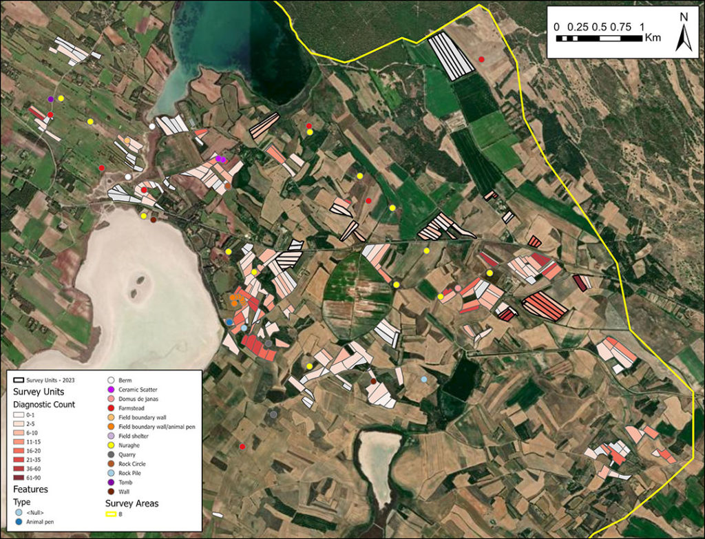
During this season, we surveyed 52 units totaling 0.323 square kilometers, bringing us to a grand total of 272 units and 1.483 square kilometers across Zone B. Our new fields were chosen based on their proximity to units surveyed in 2022 and ground visibility during the survey season, which we assessed through NDVI satellite imagery downloaded regularly. Much of this new work was in the area east of the Stagno Sale ‘e Porcus and the Stagno Is Benas, particularly in areas close to the large Nuragic site, Nuraghe Is Araus. Building on our observations from last year, we found much higher concentrations of ancient ceramics in Zone B than in Zone A, perhaps corresponding with extensive use of this landscape in antiquity and resulting from less intense farming in modern times. Our work led by team member Dr. Daniel Plekhov this year, assessing historic NDVI imagery over time, has shown that agricultural fields in this area are cultivated less frequently than those in Zone A, where large-scale industrial farms have heavily altered the landscape. Punic and Early Roman ceramics appear to be particularly pervasive in this zone, likely linked to an intensification of agricultural use of the landscape from around the 4th century BCE and continued occupation of earlier sites.
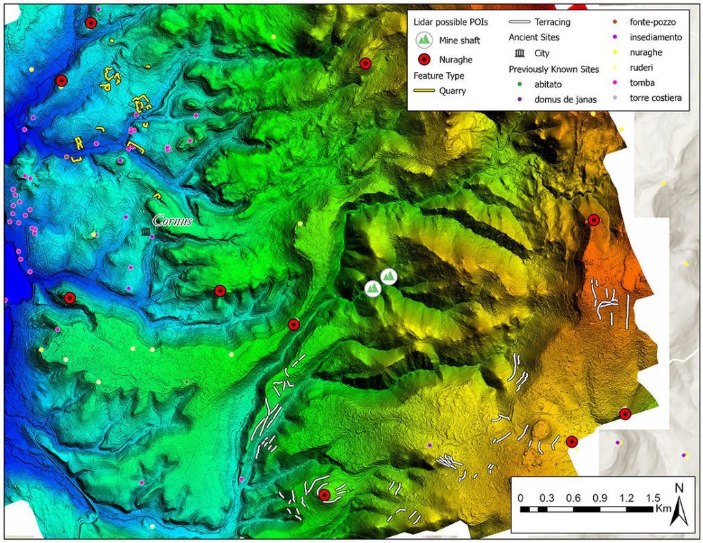
This year we also initiated work in Zone C, our northernmost survey zone, of particular interest because it is located near the settlement of Cornus and encompasses part of the Monte Ferru Mountain range. In 2021, as a part of our ongoing collaboration with the Migration and the Making of the Ancient Greek World Project (MIGMAG), Lidar (light detection and ranging) data was collected across our Zone C. Since then, our team has explored this data and other published records, complaining a list of potential quarries, mines, nuraghi, and other points of interest. This season presented the opportunity to ground-truth our findings and record some of these places. The team recorded a set of 10 features, including eight quarries and two tombs, all carved into the coastal limestone. Many of the quarries have evidence of contemporary exploitation, though some traces of ancient extraction were still visible. The rock-cut tombs documented point to ancient activities beyond stone quarrying in the immediate vicinity. This season laid the groundwork for future fieldwork in Zone C exploring additional archaeological traces of mining, quarrying, and habitation in the territory.
Finally, our dedicated laboratory team focused on processing incoming material from the pedestrian survey as well as on analysis of our ceramic finds from past seasons. We worked on refining and adding to our database with an eye toward making our data more comparable for collaborations with excavations in Sardinia and other survey projects involved in MIGMAG. We also initiated a fabric analysis on our ceramics, led by Anna Soifer, who is also conducting fabric analysis on the ceramic from S’Urachi. She used macroscopic fabric analysis to analyze a set of 759 ancient sherds collected from Zone A in 2018. This pilot study found that around 33% were locally produced within the immediate vicinity, around 21% seem to have been produced using clays from coastal areas of the Sinis Peninsula, and about 9% came from Sicily and North Africa. This method holds promise for helping us to understand clay sourcing and inter- and intra-regional trade in antiquity. It may also help us better date our ceramics based on fabric comparisons and cross-dating with excavated material from the Nuraghe S’Urachi.
Our work this season has helped us to better understand differences in settlement patterns and landscape use in antiquity in west-central Sardinia in inland (Zone A) and coastal regions (Zones B and C). Check out our Publications page for recent and upcoming presentations on our research!